Wednesday 29 August 2012

Lake of the Hanging Glaciers

For aerial glacier viewing, you can't beat the chunk of Purcells surrounding the much-discussed Jumbo Mountain, near Invermere.
One of the most glorious sites is Lake of the Hanging Glaciers. It is accessible by foot. 
The 3 hour, 16 km round trip from trail head has rave reviews in the hiking community, and why not, considering the reward?
Lake of the Hanging Glaciers, August 25, 2012

This beautiful video puts you in the scene:
Just looking at all that nimble trudging makes my healing foot ache. Much easier to view it from 10,000 feet.
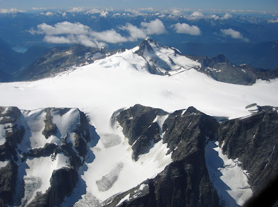
MacBeth Icefield
Spokane Glacier on Mt. Cooper


While in the area, Bill scooted around other glaciers and icefields. You can see from the horizon that he likes to get a mountain goat's view of the glacier toes! They remind me of elephant feet.
Sunday 26 August 2012

Where's my gun?

bear in our yard


Living in the mountains of BC means living with wildlife, even in the Village, it seems.
This little fellow, likely his first year on his own, appears to have adopted us. The other morning, on early departure for Calgary, Bill heard him snorting in a hollow near our compost.  Bear was none too cheered to be chased into the north woods.  That night he feasted in our crabapple tree.  The next morning he cruised the raspberry canes.  One day he ambled along the beach shoreline, in full view of swimmers, including our kiddies on the diving pole.  Another day he chased Bill and me up the cabin path from the beach and into the safety of the truck. 


bear at the beach
bear at the cabin
 http://www.bearaware.bc.ca/
Alas, things will not end well for Bear.  Despite best efforts from Bear Aware and Harvest Share (a program where volunteers pick your fruit and keep half), this fellow has become habituated to village life.  When the harried Conservation Officer out of Grand Forks catches up with his workload, Bear will be trapped and shot.  In the meantime, we carry bear bangers.

Wednesday 22 August 2012

Flying at its best!

At last a trip!  
It was time for the grandkiddies to return home after 3 weeks of idyllic summer activities. The choice?  8 hours on the road with ferry line-ups and camper traffic on the TransCanada, OR 2 hours in the air. Yes, that was the flying time, actually 1 hour 50 minutes direct Nakusp to Calgary/Springbank.  
We did a one day round trip, circle route. With the drive to and from Nakusp, the walkaround and loading, the fuel and lunch stop in Springbank, the shutdown and hangaring, the grocery shopping on the way home, we were gone from the house for 9 hours.
Supervising the walkaround
It was a glorious, perfect blue sky day! We started and finished early to beat the thermals and bumpy air that build up during daytime heating. Our route and accompanying photos are displayed in this Spot Adventure link:
http://www.findmespot.com/spotadventures/index.php/view_adventure?tripid=313656
As well as functioning as an emergency beacon, SPOT takes GPS readings every 10 minutes, and records these as tracking points. The route that you see is actual, not drawn. If you are following the blog, please motor around in the Spot Adventure site and become familiar with its features - the zoom and drag; map vs. satellite background; larger view of photos by clicking on the photo strip. I like this format, and couldn't possibly do a better job of trip summary.
Castle Mountain, 8,500 feet
Photo of the day is Castle Mountain, a site that never fails to impress. Imposing by road, it is majestic by air.
http://www.peakfinder.com/peakfinder.ASP?PeakName=castle+mountain+%28alberta%29
This amazing structure was a fine tribute to General Eisenhower during the 33 years it bore his name, but let's face it, "castle" fits!
Speed train in Albert Canyon
Finally, a train photo for Jay, along with the observation that it is a good time to hold CP shares. For the first time in years the rail yard in Field was empty, which means the rolling stock is hauling freight.  Hunter Harrison is not wasting any time turning around our national railway.

Wednesday 15 August 2012

Tracking

Airplanes are like All Terrain Vehicles: point in any direction and go. Literally, the sky is the limit!
Of course, there are some rules, for example maintaining a cruising altitude determined by whether you are flying east or west. The more congested the airspace, the longer the rule book. You can't fly into the Lower Mainland or major cities unless your plane is equipped with a transponder. This allows you to be identified by a blip on a radar screen. You fly very prescriptive approaches and departures, and are yelled at by Air Traffic Controllers if you deviate.
Before we take off - anywhere - Bill files a flight plan with Nav Canada. His flight path to the Coast goes like this: "Nakusp departure, overhead Kelowna, GPS direct to overhead the Coquihalla Toll Booth, overhead Hope, overhead Chilliwack to Kilgard check point, direct Boundary Bay." He estimates an arrival time, must close the flight plan on landing, and has 30 minutes grace before Search and Rescue goes into action.
Although little information has been released about the recent crash out of Penticton, two facts have been: the Piper deviated from its filed flight plan; activation of the plane's ELT (Emergency Locator Transmitter) directed SAR to the accident site almost immediately.
ELT easily accessible

Most Canadian aircraft are required to carry a functioning ELT. We fly to Creston every second year to have ours checked and certified by a specialized technician.  Our ELT is mounted beside the left rear seat, and that passenger is instructed not to play with it, as we don't want a SAR Buffalo suddenly appearing on our wing tip! It can be activated by hand, and theoretically emits a signal when the plane crashes. In practice, it fails to activate more than half the time - appalling in this age of technology. Controversy abounds on how planes can be better tracked:
http://www.avweb.com/blogs/insider/Time_To_Replace_ELTs_203244-1.html
For redundancy, we carry a Personal Locator Beacon in the form of a SPOT device. It has a 911 button that broadcasts our GPS coordinates, providing it sees the satellite.
handy SPOT
In the case of the Piper - miles off its flight plan, in wooded terrain - the ELT worked, and people are alive as result.

Tuesday 14 August 2012

Crashes

Yes, planes crash.  So do cars, snowmobiles and bikes, often with deadly results.  Although we have a greater chance of being flattened by a chiptruck on the way to the airstrip than flying into a rock wall, facts are no match for irrational fears.  The media feeds fears with a wonderful job of reporting each and every air accident.
A Piper crashed out of Penticton yesterday on a route that we take each time we fly to the Coast.  We know the Brenda Mine site well. It sits at about 5,000 ft elevation, just east of the summit of the Connector.  It's a stunning distraction in a boring landscape that I usually knit through.
Brenda Mine site, July 6, 2012
Although we normally overfly Kelowna at 8,500 feet and notify the Tower that we are in the airspace as courtesy only, a take-off from Kelowna or Penticton requires considerable climbing to maintain a safe altitude over the central plateau.  The hotter the day, the thinner the air, and the longer it takes to gain altitude.  The more passengers or cargo, the heavier the plane, and the longer it takes to gain altitude.  It's pretty basic physics:  if the terrain rises up at you faster than you can climb, you crash.
It will be months before this accident investigation is made public, but when it is, every private pilot in Canada will receive the results.  Education is a huge key to pilot safety.  We learn from mistakes, and thankfully, in this case, so may three of the four people in that Piper.  Our prayers are with them, and the pilot's family.
http://www.cbc.ca/news/canada/british-columbia/story/2012/08/13/bc-kelowna-plane-crash.html 

Monday 13 August 2012

New Denver Glacier

Bill slipped away from the family hub-bub last week to put more time on his new engine.  With the extra horsepower, our favourite wow-the-visitor sightseeing jaunt is easily doable in hot weather.  On takeoff from Nakusp, Bill follows Upper Arrow Lake to Burton, then hops over the back of the Valhallas to emerge on top of 'our' glacier.  Breathtaking!
New Denver Glacier from bedroom deck
New Denver Glacier, up close and personal


If I could find and scan a similar photo taken when I first saw New Denver (1964), there would be far more ice and snow.  Global Warming or natural ebb and flow?  No doubt in this valley.  The receding glacier has been well-tracked:
http://www.slocanlake.net/glacier_.html 

The climber in this video has a pessimistic opinion of its demise: http://www.youtube.com/watch?v=h0_q1AK8TT0 

Here's the view of New Denver that his camera could not capture, thanks to Chris who snapped this on a similar flight path in July 2009:
Overtop New Denver Glacier with Village beyond

Monday 6 August 2012

Above New Denver

One of our favourite flights is very close to home - 5,000 ft above the house!
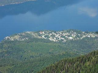
New Denver, population 556
Carpenter Creek bisects the Village, with the Orchard, Health Centre, Campground, and Marina on the south side.  To the north are Main Street and the school.  Our house is at S-curve at the far north of town.  Our cabin is on Bigelow Bay, a two minute walk down the forested hillside.
Distances are small in our tiny, perfect Village!
A different kind of flying: Jay on the Laser, Bigelow Bay


Today there was an excursion to Idaho Peak lookout.  It's a 12 km drive from Sandon on a bumpy mostly one-vehicle-wide forestry road, followed by a 40 minute hike along a ridge.  At more than 5,000 ft above New Denver, it is almost like being in the plane!
Alamo Basin, on climb to Idaho Peak
Slocan Lake and New Denver from Idaho Peak
The spectacular views make it our most popular tourist destination.  With the snow at that elevation (7,400 ft), Idaho Peak is accessible only briefly mid-summer. If you miss the window of opportunity on your visit here, catch this 360 degree view from the old Forestry Lookout:
 http://www.youtube.com/watch?v=TgQ18laviO0